Map
The Map page in Manager's viewer configuration area has settings that allow you to extend or restrict the scale range of the map and configure the map's coordinate system.
Open the Map Page
To open an HTML5 viewer's Map page in Manager:
-
In
 beside the viewer.
 -
In the side panel, click Map.
Scale Range Settings
The Override Scale settings enable you to override the default scale range of the map.
By default, the primary map service determines the scale range of the map. The map's Zoom control has the same range as the map's primary map service. Each level of detail in the primary map service is one zoom level in the Zoom control. Users cannot zoom in closer than the primary map service's minimum scale, or zoom out farther than the primary map service's maximum scale.
A site may contain a service, often a dynamic service, with a larger scale range than the primary map service. In this case, users will not be able to see the entire map service—they can only see the part that lies within the primary map service's scale range. The Override Scale settings enable you to extend the map's scale range so users can see the parts of the map service that lie outside the primary map service's scale range.
You can also use the Override Scale settings to restrict the map's scale range.
The scale range settings are:
-
Override Minimum Scale: The minimum scale at which the map is visible in viewers. For example, if the map's minimum scale is 1:5,000,000, you could extend the minimum scale to 1:10,000,000 in Essentials.
To configure the minimum scale, enter the scale's denominator, without commas or other punctuation. For example, to set the minimum scale to 1:10,000,000, enter 10000000 in the Override Minimum Scale box.
-
Override Maximum Scale: The maximum scale at which the map is visible in viewers. For example, if the map's maximum scale is 1:2,000, you could extend the maximum scale to 1:500 in Essentials.
To configure the maximum scale, enter the scale's denominator, without commas or other punctuation. For example, to set the maximum scale to 1:500, enter 500 in the Override Maximum Scale box.
Map Coordinate Systems Settings
The Map Coordinate Systems settings allow you to control how the map coordinates are displayed.
The map coordinates show the position of the mouse pointer. By default, the coordinates appear at the bottom left of the map, beside the scale bar:
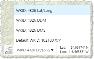
Map coordinates with the coordinate system menu open
The map coordinate systems settings are:
-
Default Coordinate Display Types:
-
Decimal Degrees (Lat/Long) - Default Geographic Coordinate System Spatial Reference: To include the default geographic coordinate system displayed in latitude and longitude, select this checkbox. By default, this checkbox is selected.
-
Degrees Decimal Minutes (DDM) - Default Geographic Coordinate System Spatial Reference: To include the default geographic coordinate system displayed in decimal degrees and minutes, select this checkbox. By default, this checkbox is selected.
-
Degrees Minutes Seconds (DMS) - Default Geographic Coordinate System Spatial Reference: To include the default geographic coordinate system displayed in degrees, minutes and seconds, select this checkbox. By default, this checkbox is selected.
-
Projected Coordinates (X/Y) - Primary Map Spatial Reference: To include the primary map's projected coordinate system displayed in X and Y, select this checkbox. By default, this checkbox is selected.
-
-
Default Geographic Coordinate System WKID: The well-known ID of the default coordinate system. The default is 4326.
For a list of WKIDs, see Esri's Geographic Coordinate Systems or Projected Coordinate Systems documentation.
-
Coordinate Decimal Precision: The number of decimal places to use for coordinates. The default is 5.
This precision setting cannot exceed the maximum representable IEEE 754 floating point. This is specified in the IEEE 754 standard. See double-precision floating-point format and significant figures for more information.
-
Alternate Coordinate Systems: A list of coordinate systems to make available as options in the Map Coordinates map widget. To add a coordinate systems, click Add and configure the settings:
-
Display Name: The name to display in the Map Coordinates map widget.
-
WKID: The well-known ID of the coordinate system. Cannot be set if WKT is already specified.
For a list of WKIDs, see Esri's Geographic Coordinate Systems or Projected Coordinate Systems documentation.
-
WKT: The well-known text of the coordinate system. Cannot be set if WKID is already specified.
For a list of WKTs, see Esri's Geographic Coordinate Systems or Projected Coordinate Systems documentation.
-
Output Labels: The units to use for the coordinates. Possible values include:
-
Output Labels: The units to use for the coordinates. Possible values include:
-
DDM: Degrees, Decimal Minutes
-
DMS: Degrees, Minutes, Seconds
-
Lat/Long: Latitude, Longitude
-
X/Y: X, Y (in the units of the coordinate system)
-
MGRS: Military Grid Reference System, if configured
-
USNG: United States National Grid, if configured
MGRS and USNG are not supported in offline mode.
For example, to configure the MGRS coordinates:
-
Click Add under the Alternate Coordinate Systems field to open the Add/Edit Coordinate System dialog.
-
Type a name for display purposes in the Display Name field.
-
Leave the WKID and WKT fields blank.
-
Select MGRS in the Output Type list.
-
Click OK to add MGRS as an alternate coordinate system.
-
Click Apply Changes and then Save Site.
-
Refresh the Viewer if it is open.
MGRS is now available as a selection in the list of coordinate systems.
-
-
-
See also...